beautiful

Kapu – a delightful beach in South India

Travel and Places

About 15 kms south of Udupi (on the way to Mangalore) lies a delightful strip of sand and surf called Kapu.

______________________________________________________________________________


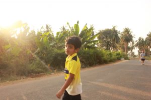
I had come to Udupi to meet my nephew, who studies at the Manipal Institute of Technology. One morning during my two-day stay there, I found myself free. My nephew would be in class till the afternoon, after which he would meet me. On a sudden whim, I decided to visit one of the beaches dotting the beautiful coastline of Dakshin Kannada (meaning, South Karnataka). After some serious thought (because there is an overdose of options), I plumped for Kapu beach (some locals call it Kaap). Kapu was most convenient for a half-day trip, because it is situated just 15 kms from the town of Udupi where I was shacked up. Buses were frequent. I could visit the beach and be back in time to meet my nephew.

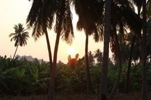
After a breakfast of medu vada and dosa, accompanied by coconut chutney and sambar, I boarded an ‘express’ bus to Mangalore. Unlike regular buses, express buses take the highway to Mangalore and do not get into country roads. They are therefore much faster than their ordinary cousins. About 25 minutes later, I was deposited at the Kapu junction on the same highway. The ticket cost me all of Rs. 18. On the way, I was treated to delightful vistas of coconut palms and arecanut trees, old-style houses with brown tiled roofs, ponds and lagoons and small shops lining the highway. The landscape here is very similar to that of Kerala, since Dakshin Kannada lies just north of Kerala along the same coastline. Even the cuisine (especially the seafood dishes) are prepared and eaten the same way as in Kerala.

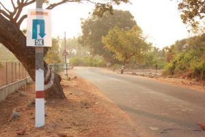
Disembarking from the bus at Kapu junction, I took an auto to Kapu beach. The ride cost me Rs. 30/- . Autos have fixed fares from the junction to different places in the area. Bargaining is not of much use, since the auto drivers operate as a union. Passing through shaded country roads with houses on either side (and even the odd motor garage), I reached the beach in 5 minutes.


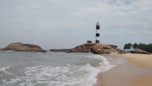
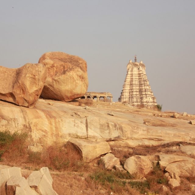
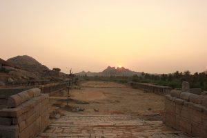
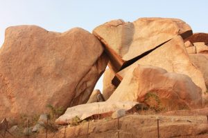
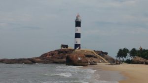
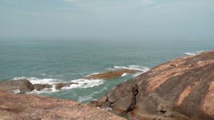
Standing at the entrance to the beach, I took in the entire stretch in one glance. Close by to my right at one end of the beach stood the lighthouse, a somewhat grim and lonely apparition rising into the sky. To my left, the sandy strip curved a long way until it ran into a clump of boulders that marked the other end of the beach. A concrete pathway had been built along the inner edge of the beach and stone benches had been built along this. Through the intense haze of the summer morning, I could see that the beach was deserted. There must have been just a dozen people scattered along its entire length. Some of them were lounging on the benches in the shade of coconut trees (understandable, given the heat), but surprisingly, some other were frolicking in the rushing waters. But then, I remembered that while even during the height of summer, the sea water is cool.

After standing in the water myself for a few minutes, I started walking towards the lighthouse. At some distance into the sea, I could see a lone fishing boat bobbing in the waves. This fisherman must have come late to the fishing party, I speculate idly. Or maybe, he just had a refreshing beer and gone off to sleep. The instant this thought flashed through my mind, I yearned for a bottle of cold beer myself. My thirst for beer was so bad in that instant, that the hair on my arms bristled and I could clearly feel the parched bottom of my throat.


I had to climb up three flights of stairs to reach the base of the lighthouse (because it was perched on top of a boulder). I saw to my disappointment that it was closed. I could not spot the caretaker either. It wondered if it is an abandoned lighthouse. Or maybe it would open only at night, when ships and boats had to be guided. Climbing to the top of lighthouses and gazing out in all directions is something I love doing. I have done it in several places, like Chennai, Kannur and Daman.


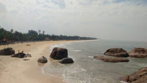
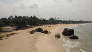
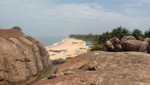
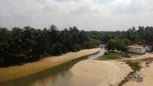
Not finding anybody to ask, I plonked myself down in the shade of the tall structure. This vantage point gave me a different perspective of the whole area. To my right, I saw another beach stretching out into the distance. A few fishing boats were parked on the sand and a few mesh nets spread out next to them. The fishermen will claim them again before dawn the next day, when they put out to sea in search of fish. On another side, a shallow stretch of backwater flowed past to form a lagoon. Far away into the sea, I could make out a few dots. I assumed them to be cruise or cargo ships. The breeze was mild. It was all very peaceful and life seemed very good from my perch. It seemed better still, when, a moment later, I remembered that I was lazing on a beach on a weekday.


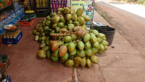
I did want to get into the water and splash around a bit, but the sun was too harsh for that. Instead, I had a super-refreshing tender coconut and caught a bus back to Udupi.


I am going to return to the Udupi belt during the monsoon this year, when this whole belt will be lush and wet. I just can’t for that.

The vitals

  • The fastest and cheapest way to reach Kapu is to take an Express bus from the private bus stand, which is locally known as service bus stand also. The bus ride to Kapu junction on the highway takes about 20 minutes and costs Rs. From the highway, take an auto to the beach. This ride cost me Rs. 30/- one way in March 2018.
  • The waves in the beach are wild; so, tread carefully in the waters. I did not see a lifeguard around.
  • This is a relatively unspoilt beach. . The local village council & citizens take pains to keep the beach clean. Let us help them keep it that way. Look for trash bins to dump your trash in. Alternatively, put your trash in your bag and bring it back to your hotel to dump.
  • There are no resorts or hotels close to the beach. Thank God for that.
  • For accommodation, Udupi is the nearest town. It will make sense for you to stay there, also because Udupi has other attractions, and is a bus & rail hub.
  • Summer (I am talking temperature in the high thirties & extreme humidity) is from March to early June here, after which the monsoon sets in. The monsoon is a magical time to visit this place in. Failing that, you could go anytime between November and February.
  • If you keep about a week, you can cover a few lovely places in the Dakshin Kannada belt.
  • Most people here have a traditional mindset and lifestyle; so, covering up adequately and not being boisterously Bohemian would be a very good idea.
  • Sample the seafood and vegetarian food, both of which are yummy in these parts. In fact, a number of people have migrated from Udupi to various parts of India and set up vegetarian restaurants. These restaurants are famously called Udupi restaurants, especially in Chennai, Pune and Mumbai.

________________________________________________________________________________


Show me some love. Like and share this post.

The magic of Malabar

Travel and Places


Though few people know this, the northern part of Kerala has as much to offer a traveler as its southern counterpart. Ask anybody about Kerala, and you are likely to hear about its backwaters and houseboats, its swaying palms, its beaches (especially Kovalam) and the dance form of Kathakali. Someone slightly more knowledgeable about the place would probably tell you about Fort Kochi and its old-world ambience (including Jew Street, which is the last remnant of a once-strong sub-culture of Kerala), the Ona Sadya (a traditional feast served during the festival of Onam) and the annual boat races of Alleppey. Over the years however, few visitors to Kerala have bothered to look at what lies North of Kochi.

You’d be amazed at all Malabar has to offer—mountains, rivers, untouched beaches, forts, old-world towns, bazaars, museums, temples—there’s something here for everyone. Malabar is the region that starts from Malappuram (just north of Palakkad) and stretches right up to the northern-most tip of Kerala. A princely state till 1956, this is where Vasco da Gama first set foot in India in the 15th century, thereby laying the foundation for the globalisation of Kerala. Through the centuries, commerce has always flourished in the region, but when it comes to tourism, Malabar has always eluded tourists. The next time you think of visiting Kerala, add Malabar to your itinerary, and you’ll come away charmed.

Kannur 

The magic of MalabarPhoto by:  freebird (bobinson|ബോബിന്‍സണ്), Creative Commons Attribution Licence

Kannur was the seat of the Kolathiri rajas and the Arakkal dynasty. The main attractions here are its beautiful beaches, temples dedicated to Muthappan (Lord Shiva in his incarnation as a hunter) and the enthralling dance form of theyyam. Angelo Fort, a couple of kilometers from the centre of town, is a legacy of Kannur’s earliest foreign settlers, the Portuguese. The sprawling fort is rather well-maintained and offers a stunning view of the sea from its ramparts. Out of the beaches, the beaches of Muzhappilangad and Thottada are secluded and definitely worth a visit. Visit a handloom weaving centre for some great bargains, and if you’re culturally inclined, take in a theyyam dance performance at a local Muthappan kaavu. Round off your stay in Kannur with a visit to the Arakkal Museum, which is a repository of royal possessions from the days of the Arakkal Dynasty.

Kozhikode 

For most tourists, Kozhikode is a jump-off point on the way to Wayanad, or a snacking halt during the long haul over the mountains to Mysore or Bangalore. But pause a while and look around, and you will see that Kozhikode throws up a mélange of flavours. For centuries, it has been the bustling capital of commerce in Malabar, and is one of the oldest ports in Kerala. The older sections of the city are known for their bazaars and wholesale markets—you can buy a bewildering variety of spices here at extremely reasonable prices—and the city is dotted with beaches like the Kappad beach (the exact spot where Vasco Da Gama landed in Kerala), Kozhikode beach and Payyoli beach. When you have had your fill of the sea, head over to the bountiful hills for a dose of trekking and a bath in the Tusharagiri Falls. Sightseeing aside, Kozhikode is a great place for foodies—head to Hotel Paragon on Kannur Road for some excellent Malabar biryani, appam and kadala curry—and indulge your sweet tooth with some delicious Kozhikode halwa.

Bekal Fort 

Between the towns of Kannur and Kasaragod lies Bekal Fort. Around 300 years old, it looks like a giant key-hole when seen from above. Abutting the Arabian Sea, it stands like a proud sentinel—which indeed it was in the olden days—guarding the city from marauders approaching from the sea. Thankfully, it has been well-preserved, and exudes oodles of atmosphere. You can see the tall observation towers, from where huge cannons used to be fired during battles.

Nilambur 

Nilambur is practically hidden from the eyes of the world. Situated off the trunk route, it is a charming little town with an undulating terrain. Though its tree cover has reduced over the decades, it is still green enough to send you into a trance. Teak plantations abound, and so do old mansions. You can find the oldest teak plantation in the world—called Conolly’s plot—here, and there’s even a teak museum on the premises. In Keralan history, Nilambur has always been known for its kovilakams (stately manors that were once the residences of princely families of yore). Built according to traditional norms of architecture, kovilakams are beautiful structures of wood and laterite, with inner courtyards, intricate etchings on the ceilings, and extensive slat work. The forests of Nilambur are home to a number of elephants, and trekking along the elephant corridors is a delight. There’s a large variety of accommodation to choose from, although you should plump for the homestays—which offer a good combination of beautiful architecture, old-world hospitality, solitude and good food.


Show me some love. Like and share this post.

Bengaluru to Agumbe: Rains and akka’s abode

Travel and Places

A village enveloped in thick, white fog, the monsoon, and memories of ‘Malgudi Days’.

This story first appeared in Mint on Aug 26, 2016 under the section ‘Weekend Vacations’.

____________________________________________________________________________


The Jogigundi Falls in Agumbe. Photo: Ganesh Vancheeswaran


I stepped off the bus and walked right into a white wall. Turning around, I saw the white wall creeping up behind me. It took a few seconds for my dazed mind to realize that it was actually thick fog. Almost animate, it was on the prowl, gliding without warning, and wrapping itself around the entire village.

A friend and I were in the hilly hamlet of Agumbe in the Western Ghats. An overnight bus journey from Bengaluru had brought us here for a weekend getaway to savour the magic of the monsoon. After all, Agumbe is one of the wettest places in India.

We had to trudge only 200m to Kasturi akka’s house (akka means elder sister in Kannada) from the bus stand. Locally known as Dodda Mane (big house in Kannada), it’s a village landmark.

Akka’s family has been giving sanctuary to weary travellers for 45 years, essentially converting Dodda Mane into a home stay much before the word started occupying an exalted position in the hospitality industry in India. This two-storeyed, traditional Malnad house, built with teak wood and stone, is more than 125 years old. Thick wooden columns line the front court; beyond it lies a central courtyard with potted plants circling it. From there, stout doors lead to the bedrooms and the kitchen.

Despite its rambling spread, there is a curious charm about it.

Akka’s son showed us to the rooms and dormitory on the first floor. The wooden stairs creaked under our feet. The sound was enough for the dame of the house to holler to ensure that her guests were okay and tell us that we could join her in the kitchen if we liked.

The kitchen had an old-fashioned brick stove, with large cucumbers hung above it to dry. At the corner of a large vintage table sat akka. The introductions happened over breakfast.

The first day was reserved for a trek to the Jogigundi Waterfalls, about 4km away. We logged a kilometre on the paved road before veering on to a forest trail. The slushy dirt path, with small, slippery rocks, put us to the test. The tall trees made a thick canopy above our heads and slim streams formed temporary capillaries around them. Thankfully, it had stopped raining.

The silence of the forest was punctuated only by the call of crickets and cicadas. We were about an hour into the trek when we heard a rising roar, an indication that we were nearing the waterfall. Stepping over fallen logs and walking down mossy stone steps, we parted the thick foliage to emerge at the base of the waterfall.

The Malapahaari river was rushing thunderously over boulders. It emerged from a cave-like formation, flowing down in a long trail over a series of rocks. We got as close as we could to the water, feeling the misty spray on our faces.

A couple of hours later, we headed back—and relaxed in the courtyard of Dodda Mane. Dinner that night was an excellent Malnad-style repast—high on vegetables and low on masala (spices) and oil.

There were no arguments about whether the next day should be dedicated to akka’s stories and a generous supply of kashaya (a herbal concoction). We decided to forgo the trip to Sirimane Falls (38km away) and the temple town of Sringeri (29km away). And over several cups of kashayaakka and her family recalled the days when a few shows of the TV serial Malgudi Days had been shot in that very house.

By noon, the monsoon was living up to its promise, and fat drops of rain were exploding again on the roof of the house. The downpour came as a tonic, and we decided to take a short ride to an ancient Jain temple (19km).

We climbed the steps to the top of the temple and walked to a rocky outcrop at the rear. Volunteering to get slammed by the wind, we looked out at the outrageously green valley, punctuated by capillaries of freshly created streams.

It didn’t take long, of course, for the fog to blot out the scene.


Show me some love. Like and share this post.

A breezy summer holiday in Sakleshpur

Travel and Places

With coffee estates, lovely treks, waterfalls and encounters of the wild kind, Sakleshpur can surprise you. Do yourself a favour and go there right away.

_______________________________________________________________________________

It was a spur-of-the-moment decision. One moment, we were chatting about heading back into the hills and the next moment, we had decided to go to Sakleshpur the next day. This is how we decide on most of our trips, because it goes with our personality (of not thinking and planning too much and leveraging the spontaneity of the moment). We had visited Fort Kochi as a family just three weeks ago (and I had packed in a solo trip to Madras/Chennai after that), but already, there was this strong itch to go away somewhere again.

So we set out Saturday morning by car. We have heard that the train route from Bangalore to Sakleshpur is also scenic, but we kept that for another time. Leaving home at 5 am (to avoid the traffic nightmare that invariably descends on this city as early as 6 am), we were in Nelamangala by 5:45. A brief stop for a cup of tea and we were on the move again. Reaching Chennarayapatna at about 8:30, we breakfasted at Adyar Ananda Bhavan (AAB). We’d have preferred a smaller outlet that was more ‘local’ in nature, but there was nothing like that for a long distance. And so, AAB it was.

When we set out again after this pit stop, it was 9 am. We breezed through Hassan, after which the road became a little narrower and rougher (but it was still reasonably good). We reached our guest house at exactly 10:30 am, 5 hours after we left home. It was a comfortable ride overall, and if you consider the two halts, I’d say we made good time.

Our guest house was nothing fancy; but, it was clean and comfortable, with excellent views of paddy fields on one side and a jungle on the other. I wondered about its fancy name (Butterstone River Valley), but forgot to ask the manager about it.

We checked in and lazed around for a while, stretching our cramped muscles and just settling down. An hour or so later, we walked over to a waterfall nearby. The leisurely ten-minute stroll took us past humble houses built in the Malnad style, piles of logs kept on the roadside (and to be used to make a fire later on, I guessed), coffee plantations and rough-hewn paths that led into the forest. It was good to be walking in the hills again– my mountain-loving soul was on song!

The small sign board said ‘Abbi Falls’, although the manager of our resort had called it ‘Habbi Falls’. Nothing much in the spelling, really. It is quite common to find different spellings of the same name in India, with one syllable more or less. One of the funny things about this country is that, with its varying languages and dialects, it is enough to be able to pronounce a name somewhat correctly – an approximation of sorts.

A short, but slippery descent through a mud path took us to the waterfall. We heard the sound of the water just before we turned the final bend and emerged from a clump of bushes. At first glance, it was nothing much; the water plunged about 25 feet after which it eddied for a bit amidst the rocks before forming a stream. But as we started moving towards the fall, we realized that the rocks and pebbles were slippery. Some tricky negotiation of this stretch and some Dutch courage took us to the point where the water was plunging down. It was then that I realized that the water was falling with considerable force, even though the height wasn’t much. We slipped into the water (cold and so refreshing) and stayed there awhile. Much kicking, splashing and squealing happened. After a time, I ventured past the water eddies and sat directly under the water’s flow. Fat drops of water now hit fell on my head and back directly, making me feel the force of the current anew. I emerged from the water curtain after about twenty minutes, feeling thoroughly refreshed and my skin tingling.

We then sat on the rocks for a long time, letting our clothes dry in the warm sun. The warmth of the sun was in contrast to the cool breeze – it was a feeling to be savoured. So far, we had had the place practically to ourselves, but now a small crowd arrived. We sat there, idly watching them, letting the breeze caress our bodies, listening to the sound of the insects in the forest, wondering at the continuous rush of the water….time just passed.

Finally, reluctantly, we dragged ourselves from that spot and trudged back to our resort for a hearty (and well earned) meal. Predictably, we felt heavy-lidded after lunch and crashed in our room for a couple of hours. Awaking in the late afternoon, we found some piping hot filter coffee waiting for us. I had forgotten all about coffee!Sakleshpur is coffee country, home to thousands of acres of coffee plantations. So no wonder we were being offered some fine coffee by the resort. A leisurely cuppa later, Shankar who works at the resort, offered to take us on a plantation walk.

The plantation was about 80 acres in size (small, as plantations go), but it was in the midst of a thick jungle. Our path was rocky at places and highly uneven, which meant that we really had to focus on it. At particularly steep stretches, I could feel my sinews stretching. I remember thinking that this was proving to be more of a trek and less of a plantation walk. Coffee had been planted in between a variety of native tree species, forming a thick jungle. As we hiked, Shankar pointed out coffee bushes and explained how coffee is grown. Apparently, it takes about a year for the coffee beans to sprout. Of the different kinds of coffee, Robusta and Arabica are the predominant varieties in Sakleshpur. They differ in taste and aroma. Sprinklers meant to water the bushes punctuated our trail.

We kept up a steady pace, trying to concentrate on both the tough trail and Shankar’s monologue. After about forty minutes of hiking, we stopped for a short breather. Silence enveloped us, broken only by our slightly ragged breathing. We took a few pictures of the scene. Charu (the wife), said ‘Oh, look. There is a bison.’ And when I turned to look, there indeed was a bison. About seven feet tall, he seemed to be gazing at us calmly. And we gazed back at him calmly. He was standing on the edge of the path, half inside the bushes, about twenty feet from us. But it was when Shankar saw the animal too that all hell broke loose. He just whispered ‘Run!’ at us, turned and matched action to word. Nonplussed by this unexpected turn of events, we stood rooted to the spot for a moment before Shankar’s feverish ‘Run (exclamation) reached our ears a second time. The blood gushed through our veins and we started running. Honestly, I should call it scrambling. We ran blindly for God knows how long. We ran back the way we had come, our minds a total blank – except for the fact that, by now, we had realized that the bison could be a very dangerous customer indeed, inspite of his benign expression.

I don’t know how far we ran, huffing and puffing. I had the extra task of holding on tightly to my DSLR, a task that suddenly seemed onerous. My legs felt like chunks of lead and my lungs were on fire. As we ran, I was haunted by the thought that any moment now, the bison could gore us into the ground from behind. And finally, when we felt we couldn’t run an inch more, we stopped. The silence and calm around us was in shocking contrast to the turmoil in our heads. As our breathing returned to normal, we started walking slowly. Shankar assured us that we were out of danger now.

Reaching our guest house, the first thing I did was to imbibe some stuff far stronger than coffee. God knows I needed it. As I sat on our porch afterwards, I thought back to the experience. Somehow, it felt unreal. But the fear and exhilaration coursing through my mind were telling me that it had been all too real.

We sat on the porch for the rest of the evening, reading, chatting and enjoying views of the now-golden paddy fields. Dinner was a subdued affair, because we were happily tired.

We set out early the next morning, after some more of that wonderful filter coffee. We drove about 10 kms from the resort, parked the car and then trekked up to a peak that was perhaps a kilometer away. This and two other peaks that were close by, we together called Byreshwar Gudda (‘gudda’ means peak in Kannada). The name is actually that of the deity of a small temple close to where we had parked our car. Byreshwar is a common deity in Karnataka, and an incarnation of Lord Shiva. The peak was open on three sides, offering us a stunning, 300 degree view of the valley and the ranges yonder. Behind us, a steep path rose up to another cliff.We were there for a long time, taking pictures, enjoying the view and lying down on the moist grass. A wind was gusting and the sun was slowly warming up to the day ahead. Shankar pointed out an elephant corridor in the distance. Places like this shoo away all thoughts from your mind and compel you to live in just that moment. Looking up, I badly wanted to gather the deep blue sky in my arms.

We spent an hour on the peak, before carefully picking our way down. As we were walking, a small stone temple hove into view. This was the temple that has given the peak its name – Byreshwara Devasthana. Local legend says that the Pandavas built it and dedicated it to Lord Shiva as part of their prayers to the yogi God. Such legends abound in a country like India. There is no way one can verify them. And so, the best one can do is to take the legend at face value. And before you know it, the place automatically acquires a sense of history and atmosphere. Inspite of the plain stonework, the temple looked elegant. The still-soft sunrays formed a halo around the temple crest. The design of the crest looked unique to me – fashioned into a nine-step arrangement, it was like nothing I had seen in any other temple.

We drove back to our resort in silence, our minds stilled by the lovely experiences of the morning. Breakfast was a simple but tasty affair, comprising spicy sevai (rice vermicelli), akki roti and coconut-garlic chutney. We chased down the meal with tumblerfulls of – what else? – filter coffee. We then had a quick bath and checked out of the resort. In leaving, I managed to buy some coffee powder from the manager of the resort. The powder had been sourced from their own estate, the one we had walked in the previous evening.

Driving back to Mangalore Road, we stopped at Manzarabad Fort – our last halt of the trip. It seems that outside the Sakleshpur region, hardly anybody knows about this fort. And yet, it is a thing of beauty, tucked away amidst forests and coffee estates. We had to park the car on the main road and go the rest of the way on foot. Steps with a railing have been laid to make the climb slightly easier for people. We counted 255 steps from bottom to top in what was a short, but steep climb.

As forts go, this one is small. Its visual attraction is that it is built in the shape of a star, though I realized that you’d have to view it from a helicopter to make out that shape. This fort was extremely important to Tipu Sultan, because it helped him guard the ghat ranges in this part of Mysore Province, of which he was the ruler. At that time, he had to fight continual battles with the British, the Marathas and the Nizam of Hyderabad. Like other old forts in many parts of India, this one too is in reasonably good shape (it was built in 1792).

We walked past the old garrison, peeped into dark chambers and admired the step-well built right in the middle. Bending and walking through a narrow passage, we emerged inside a watch tower. This must have been where soldiers would have stood centuries ago, guns at the ready, not knowing when the enemy would attack them. The broken ramparts of the fort gave us a sweeping view of the surrounding hills.

Our drive back to Bangalore was smooth. We made it home in exactly five hours (including a halt for lunch at Kamat Restaurant near Channarayapatna). As we sat sipping ginger tea at home, we thought back to the lovely place we had left behind and started making plans to return there.


Sakleshpur – fact file

  • The Sakleshpur region is about 4000-4500 feet above sea level. Situated on the Bangalore-Mangalore route, it takes a running time of 4 hours by train or car.
  • Apart from coffee, pepper and cardamom are also grown here. The salubrious climate makes it good for growing spices.
  • Sakleshpur forms part of Malnad, a socio-cultural name given to this part of Karnataka. The word ‘Malnad’ comes from ‘maley naadu, which means ‘hill country’ in Kannada. Houses in this region are characterized by sloping roofs clad in elegant brown tiles and a colonnaded porch for people to relax in.
  • By and large, this area is unknown to people living outside Karnataka. As of now, most tourists to Sakleshpur come from Bangalore.
  • Other than tiny, dubious-looking eateries, there aren’t many good options on this route. It is therefore best to stop at Adyar Ananda Bhavan in Chennarayapatna. Though overpriced, the food is very good. Kamat Restaurant, diagonally opposite Adyar Ananda Bhavan, is really not worth it.
  • We stayed at the Butterstone River Valley, a guest house that is about 24 kms from Sakleshpur town (where incidentally, you can buy essentials and tank up).
  • A quick sidenote about this guest house: it is good for those who want a simple, no-frills place which just lets you hang out with friends and indulge in a few team activities. You can play badminton, volleyball and mud volleyball. There is a rustic ‘swimming pool’ too (by that, I mean a tank where you can dunk youself). You get authentic Malnad breakfast, but the cooks lose their way at lunch and dinner. If you want superb all-day food, a wide menu, personalized service, a well-appointed room and the trimmings of a real resort, this place won’t cut it.
  • When we went there (April 2017), this region did not have luxury resorts. Look for a good homestay that offers you scenic views, local cuisine and superb filter coffee.

When you leave, buy some coffee powder. Buying close to source will mean that you will get excellent quality at a good price. Ask the manager of the guest house for help in this regard.


Show me some love. Like and share this post.

Chasing the ruins.

Travel and Places


It was a Sunday like any other. But a run like no other.

________________________________________________________________________________

It is 6:30 am on a cool Sunday morning. I take a deep breath and look around. I see a hundred other souls like me, most of them kitted out in T-Shirts, track pants or shorts and shoes. Some of them look bleary-eyed, but the rest are on their toes already, limbering up for the run that is about to start. The place is mostly dark, but the area where we have assembled is awash with light.

The MC is on stage, talking about the run – how this run route is different from conventional routes, what to do after the run is over, etc. She then takes the assembled crowd through a basic warm-up exercises. Most people seem to be in their twenties, thirties or forties. But, I spot a few senior citizens too. One lady in particular catches my eye. She seems to be in her seventies, a little frail and slightly bent with age. She is wearing a saree, but her feet are shod in running shoes. She is accompanied by a couple of much younger people – her grandchildren, perhaps? I salute her spirit inwardly as I do my stretches.

And then, it is time. All of us move to the starting point, where a chorus of girls starts an enthusiastic (and screechy) countdown. …4,3,2,1….and GO.

Slowly, like vehicles responding to the changing traffic signal in a city, we start moving. One foot in front of the other, nudging, weaving, avoiding other feet. The crowd, which initially moved as a single block of humanity, starts breaking up a little distance ahead, as the runners start hitting their stride. The first flush of pink dusts the horizon.


The more serious runners take off at a reasonably high speed, leaving the rest of us behind. Many others (the in-betweens) are running more leisurely. And bringing up the rear are the laggards, including yours truly. Honestly, I am not here to run a timed race, eager to better my previous best and put my fitness to the test. I am treating this more like a pyjama party. And I have dressed the part too – in blue-and-white checked pyjamas, a regular T-shirt and a pair of very frayed walking shoes. What’s more, I am going to run with my camera in hand; probably the only person here who will do so!

My main agenda in coming on this run is to catch this beautiful place at a very early hour in the morning, see some of the parts that I did not see in my previous visit here and take some photos in the soft daylight. This is something I have always wanted to do, but I am hoping that the tag of a ‘run’ and the presence of a few hundred other people will motivate me to get off the starting blocks so early in the morning.

After all, it is not often that you get a chance to run through the UNESCO World Heritage Site of Hampi, taking in the beauty of its medieval ruins in the first light of the day.

I shuffle my feet and trot slowly round the first bend in the route, saluting Lord Virupaksha who is on my right. Even at this early hour, the temple is thronged by several devotees and tourists. By the time I climb the incline next to Kadalekallu Ganesha, I am huffing mildly. I stop and take a couple of photos of this small shrine, as the first rays of the sun fall on it. I marvel that it is so well preserved, inspite of being 500 years old. The slim stone pillars contain carvings that depict day-to-day life from those times.


From here, the run route hangs a left and then a right, taking you past the Krishna Temple (also built in the 16th century).  The rising sun lights up the temple’s finely-carved entrance. It seems to be in fine fettle, considering its vintage, though some restoration work is going on. Historians believe that an idol of Balakrishna was brought from Orissa and enshrined here. Across the road from the temple, the long, multi-pillared pavilion of Krishna Bazaar makes for a dramatic vista. I simply have to stop again to take in the beautiful scene. Those days, Krishna Bazaar was the groceries market. I am to learn later that Hampi had many such bazaars – including, unbelievably, a paan supari bazaar. As other runners breeze past me, I shoot a few frames of the temple and bazaar. I don’t know how long I stand there, thinking back to the time when this place must have been teeming with people. I wonder if they too haggled with sellers, like their modern-day argumentative descendants.


Next, I come upon the small, yet beautiful Chandikeshwara Temple. The animals (they seem to be lions) carved into the pillars of this temple look splendid in the soft light of the morning. The inner parts of the temple are in deep shade, but I can make out long cracks in the structure at various places. This temple is unusual, because it is one of the few in India that is dedicated to a form of Vishnu called Tiruvengalanatha. I take a few snaps and move on.


At the next bend lies another small temple with whitewashed walls – the Uddana Virabhadra temple. The whitewash is uncharacteristic of Hampi (where almost all the old structures are made of granite) and so, gives the temple a distinctive appearance.


A short distance ahead, the road passes under a stone gateway. Running under it, I emerge on the side and almost stop in my tracks when I spot several lush, green plantain trees. In fact, a whole grove of them. I am pleasantly surprised. I had never imagined finding even a patch of greenery here, in this ancient capital of the Vijayanagara empire. I wonder why all the photographs of this place show only large boulders and ruins of stone structures.


As I run, I keep sighting boulders and the ruins of centuries-old structures on both sides of the road. Many of these fabulous structures were ravaged by Muslim marauders of the time (such as the Bijapur Sultans); the rest have been eaten away by time and the elements. I wonder how beautiful these monuments would have looked in their full glory. I feel sad as I think of the destruction wrought on such beautiful works of art. As things stand, we are left to gaze at their ruins and find beauty in their decay.

I rememeber thinking at this point that Hampi perhaps has the distinction of having the maximum density of ruins and boulders per square kilometer in the world.  ‘More history per square inch’ will make a good tagline for this place.


By now, my run has turned into a full-blown quest for ruins. Though I have been here once before (a few years ago), I did not visit some of these parts back then. And so, I am full with a sense of discovery.

Unlike the other runners who are focused on the road, I keep looking to my left and right. I don’t want to miss the beauty of the route, you see? My mind is like a sponge, soaking in the sights and sounds I encounter along the way. Running with the camera does slow me down a little, but I don’t mind. I see a few other runners raise an eyebrow on spotting my camera and then smile broadly, as understanding dawns.

A short distance ahead lies another shrine – this one dedicated to Lord Anjaneya. Finding an ascetic at this shrine of the monkey god, I stop to have a few words with him. He tells me that this particular Anjaneya is believed to be all-powerful. ‘Pray here and your wish will definitely be granted.’ he tells me in Kannada. He graciously allows me to take his photograph before going his way.


This stretch of the run route is flanked by paddy fields, with the rice paddies growing to more than six feet. I am huffing again, and so, stop at a culvert to catch my breath. A small stream rushes by at the culvert. I take in the fresh air and marvel at the lushness and serenity of the place.

Soon after I resume running, I come upon a fork in the road. The right turn leads to Hospet (and seeing how desolate it is, it seems to be the road less taken), while the road ahead is the run route, going towards Kamalapur. Bang at the fork, a motorcycle is parked with a policeman sitting astride it. I wave at him and say ‘Namaskara, sir’ and he waves back. As I continue running, I spot a woman, a man and a boy walking together ahead of me. The lady is goading the little man to keep running. I catch up with them and say ‘hi’. The boy, all of six years old, is wearing a T-shirt that proclaims him to be ‘Adi’. Along with him are his mom and uncle. Apparently, his dad and aunt are running the 12 km stretch. I do my bit to motivate Adi to resume running – ‘Look, you have been ahead of even me so far. And if you keep running, you can beat me to the finish!’ After some nudging and cajoling, he resumes jogging. I mentally doff my hat at the child, who is sportingly running 5 kms over undulating and unfamiliar terrain. Talk of getting out of one’s comfort zone.


I want to run along with Adi, but I can’t. I have just spotted something intriguing and must know what it is. I see a cluster of stone slabs to my left. A closer look reveals that they are a set of roofs in the middle of a patch of green. I walk around the fenced area and find a small gate. Entering, I find steps going down to a temple. A board proclaims the site as that of a Shiva temple, lying totally underground. It is easy to miss this temple from the road, if you don’t look carefully or didn’t know about it already. This temple is sunk about 15 feet below ground level. Inscriptions found in the temple refer to it as the ‘Prasanna Virupaksha temple’, seven hundred years old. King Krishnadevaraya is said to have donated a lot of money to this temple at the time of his coronration. Today though, many pillars have fallen and stones dislodged. The walls are cracked and the corners, chipped. And yet, the temple is strangely beautiful. I can see that the halls, pavilions and sanctum sanctorum have been crafted with great love and skill.


I spend about 10 minutes taking in the place, before I run on. I am now on an upward incline on the road. To my right is what the locals refer as the ‘akka thangi gudda’ (‘Sisters boulders’ in English), a couple of mammoth boulders that seem to be conjoined at the head. Across the road from me, I spot two runners on the return leg of the run. Thinking that I am losing steam, they dole out some pep talk. ‘Don’t lose heart, buddy. Keep going. You are nearly there.’ says one of them.  ‘You don’t know the half of it’, I mumble, but smile back at the well-meaning gesture.


Cresting the incline and turning a sharp bend on the road, I see that I have reached the turn-back point. The half-way mark on the run. A few other runners are clustered here, helping themselves to the bananas and biscuits that have been laid out on tables. A volunteer is serving water. I can see smiles of relief and relaxed faces. They must all be happy that at least half the distance has been covered.


I suddenly realize that I am famished, and wolf down a couple of bananas and a few biscuits. As I am making small talk with the volunteers, Adi, his mom and his uncle also join us. A few minutes later, it is time to start my return journey. This leg of the run is quicker, because I don’t stop to click photos. Curiously however, it also seems easier than the first half. Almost before I realize it, I spot the Virupaksha Temple and a few minutes later, I am at Hampi Bazaar, the starting and finishing point.


Rajesh, my friend, has finished ahead of me and is waiting for me here. The place is teeming with people again, many of them clicking the mandatory selfies. I move to a quieter place, take several deep breaths and look back on the run – the sunrise, the beautiful ruins, the greenery, the ascetic, the underground temple. I have seen some parts of Hampi that I missed on my earlier trip to this place.

Physically, I am a little tired, but mentally I am fully refreshed. It feels like I have done myself a favour by participating in this run.


Show me some love. Like and share this post.